ENVIRONMENT
◙Biotic components=Plants/Animals/Birds etc
◙Abiotic components=Land/Mountains/Rivers etc
◙The word environment is derived from french word "Environer" meaning "Neighborhood".
◙World environment day=5 June
◙Barter system =in which, goods are exchanged without the use of money
◙Ecosystem: It is a
system formed by the
interaction of all
living organisms with
each other and with
the physical and
chemical factors of
the environment in
which they live, all
linked by transfer of
energy and material.
INSIDE OUR EARTH
Layers of Earth
1.Crust
◙uppermost layer
◙Thinnest layer
◙35 km on continental masses and about 5 km on ocean floors
◙Main minerals of continental mass=silica and alumina. It is thus called SiAl.
◙Main mineral of oceanic crust= Silica and Magnesium. It is thus called SiMa.
2.Mantle
◙It extends upto depth of 2900 km.
3.Core
◙Radius =3500 km
◙Consists mainly Nickel and Iron. It is thus called NiFe.
◙The crust forms only 1 per cent of the volume of the earth.
◙84 per cent consists of the mantle.
◙15 per cent makes the core.
◙The radius of the earth is 6371 km.
ROCKS AND MINERALS
1.Igneous (Latin word
Ignis meaning fire)
◙Also called primary rocks.
◙Intrusive ones cool slowly. E.g Granite
◙Extrusive ones are found in Deccan plateau. e.g Basalt
2.Sedimentary (Latin
word sedimentum
meaning settle down.)
e.g Sandstone
◙Red fort is made from Red Sandstone.
3.Metamorphic (Greek
word metamorphose
meaning change of form.)
◙Igneous and sedimentary rocks can change
into metamorphic rocks under great heat and
pressure. e.g clay changes into
slate and limestone into marble.
Fossils: The remains
of the dead plants and
animals trapped in
the layers of rocks are
called fossils.
EARTHQUAKES
◙Similarly, when the Lithospheric plates move, the
surface of the earth vibrates. The vibrations can travel
all round the earth. These vibrations are called
earthquakes.
◙The place in the crust where the
movement starts is called the focus.
◙The place on the
surface above the focus is called the epicentre.
◙Greatest damage is usually closest to the epicentre and
the strength of the earthquake decreases away from
the centre.
EARTHQUAKE WAVES
There are three types
of earthquake waves:
1. P waves or
longitudinal waves (PRIMARY)
2. S waves or
transverse waves (SECONDARY)
3. L waves or surface
waves (LOVE)
(*after A.E.H. Love, a British mathematician)
The other kind of surface wave is the Rayleigh wave,
◙Most of the shaking felt from an earthquake is due to the Rayleigh wave, which can be much larger than the other waves.
◙An earthquake is
measured with a
machine called a
seismograph.
◙ The
magnitude of the
earthquake is
measured on the
Richter scale.
◙An
earthquake of 2.0 or
less can be felt only a
little. An earthquake
over 5.0 can cause
damage from things
falling. A 6.0 or
higher magnitude is
considered very
strong and 7.0 is
classified as a major
earthquake.
◙There are
thousands of small
waterfalls in the
world. The highest
waterfall is Angel
Falls of Venezuela
in South America.
◙The other waterfalls
are Niagara falls
located on the
border between
Canada and USA in
North America and
Victoria Falls on
the borders of
Zambia and
Zimbabwe in Africa.
MAJOR LAND FORMS
MEANDERS
As the river enters the plain it twists and turns forming
large bends known as meanders.
In due course of time the
meander loop cuts off from the river and
forms a cut-off lake, also called an ox-bow
lake.
LEVEES
At times the river overflows its banks.
This leads to the flooding of the neighboring areas. As it floods, it
deposits layers of fine soil and other
material called sediments along its
banks. This leads to the formation
of a flat fertile floodplain. The raised
banks are called levees.
DISTRIBUTARY
As the river
approaches the sea, the speed of the
flowing water decreases and the river begins to break up
into a number of streams
called distributaries.
DELTA
The
river becomes so slow that
it begins to deposit its load.
Each distributary forms its
own mouth. The collection
of sediments from all the
mouths forms a delta.
MUSHROOM ROCKS
◙An active agent of erosion and deposition in the deserts
is wind. In deserts you can see rocks in the shape of a
mushroom, commonly called mushroom rocks. Winds
erode the lower section of the rock more than the upper
part. Therefore, such rocks have narrower base and wider
top.
SAND DUNES
◙When the wind blows, it lifts and transports sand
from one place to another. When it stops blowing the
sand falls and gets deposited in low hill – like structures.
These are called sand dunes
LOESS
◙When the grains
of sand are very fine and light, the wind can carry it over
very long distances. When such sand is deposited in
large areas, it is called loess. Large deposits of loess is found in China.
 |
| LOESS HIILS |
COMPOSITION OF THE ATMOSPHERE
1.NITROGEN (78%)
2.OXYGEN (21%)
3.ARGON (0.93%)
4.CO2 (0.04%)
◙When
we inhale, we take some
amount of nitrogen into our
lungs and exhale it. But
plants need nitrogen for their
survival. They can not take nitrogen directly from the air. Bacteria, that live in the
soil and roots of some plants, take nitrogen from the
air and change its form so that plants can use it.
STRUCTURE OF THE ATMOSPHERE
Troposphere: This layer is the most important layer of
the atmosphere. Its average height is 13 km. The air
we breathe exists here.
Almost all the weather
phenomena like rainfall,
fog and hailstorm occur in
this layer.
Stratosphere: Above the
troposphere lies the
stratosphere. It extends up
to a height of 50 km. This
layer is almost free from
clouds and associated
weather phenomenon,
making conditions most
ideal for flying aeroplanes.
One important feature of
stratosphere is that it
contains a layer of ozone
gas.
Mesosphere: This is the
third layer of the
atmosphere. It lies above
the stratosphere. It extends
up to the height of 80 km.
Meteorites burn up in
this layer on entering from
the space.
Thermosphere: In
thermosphere temperature
rises very rapidly with
increasing height.
Ionosphere is a part of this
layer. It extends between 80-400 km. This layer helps in radio transmission. In
fact, radio waves transmitted from the earth are reflected
back to the earth by this layer.
Exosphere: The upper most layer of the atmosphere
is known as exosphere. This layer has very thin air.
Light gases like helium and hydrogen float into the
space from here.
◙Thermometer:
Measures
the temperature
◙Barometer: Measures
atmospheric pressure
◙Rain Gauge: Measures
the amount of rainfall
◙Wind Vane: Shows the
direction of the wind
◙An important factor that
influences the distribution of
temperature is insolation.
Insolation is the incoming solar
energy intercepted by the earth.
The amount of insolation
decreases from the equator
towards the poles.
◙A wind is named after
the direction from
which it blows, e.g.
the wind blowing from
the west is called
westerly.
◙Winds can be
broadly divided into three types.
1. Permanent winds – The trade
winds, westerlies and easterlies
are the permanent winds.
These blow constantly
throughout the year in a
particular direction.
(The trade winds are so named because ships have historically taken advantage of them to aid their journies between Europe and the Americas.)
2. Seasonal winds – These
winds change their direction
in different seasons. For
example monsoons in India.
3. Local winds – These blow
only during a particular
period of the day or year in a
small area. For example, land
and sea breeze. The
hot and dry local wind of northern
planes of India is called loo.
RAINFALL
On the basis of
mechanism, there are three types of rainfall: 1.the
convectional rainfall
2.the orographic rainfall
3.the cyclonic rainfall
https://www.youtube.com/watch?v=i36U3LpJjzU
PRECIPITATION
MAP COMPANION (LOCATIONS TO REMEMBERS)
1.Amazon river
2. Mississippi river
3.Caribbean sea
4.Great bear lake
5.Great slave lake
6.Lake Huron
7.Lake superior
8.Niger river
9.Congo river
10.Orange river
11.Nile river
12.Mediterranean sea
13.Black sea
14.Red sea
15.Lake Victoria
16.Caspian sea
17.Arabian sea
18.South china sea
19.East china sea
20.Darling river
21.Murray river
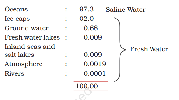
DISTRIBUTION OF WATER BODIES
We all know that three-fourth of the earth surface is
covered by water. If there is more water than land on
this earth, why do so many countries face water scarcity?
◙Salinity is the
amount of salt in
grams present in
1000 grams of water.
The average salinity
of the oceans is 35
parts per thousand.
◙Dead sea in Israel has
salinity of 340 grams
per litre of water.
Swimmers can float
in it because the
increased salt content
makes it dense.
◙March 22 is
celebrated as World
Water Day
◙Tsunami is a
Japanese word that
means “Harbour
waves” as the
harbours get
destroyed whenever
there is tsunami
◙The tsunami of
2004 caused wide spread damage in the coastal areas of
India. The Indira point in the Andaman and Nicobar
islands got submerged after the tsunami.
TIDES
The rhythmic rise and fall of ocean water twice in a
day is called a tide.
◙It is high tide when water covers
much of the shore by rising to its highest level.
◙It is
low tide when water falls to its lowest level and recedes
from the shore.
https://www.youtube.com/watch?v=pwChk4S99i4
The strong gravitational pull
exerted by the sun and the moon
on the earth’s surface causes the
tides. The water of the earth closer
to the moon gets pulled under
the influence of the moon’s
gravitational force and causes high
tide. During the full moon and new
moon days, the sun, the moon and
the earth are in the same line and
the tides are highest. These tides
are called spring tides. But when
the moon is in its first and last
quarter, the ocean waters get drawn
in diagonally opposite directions by
the gravitational pull of sun and
moon resulting in low tides. These
tides are called neap tides
OCEAN CURRENTS
1.WARM OCEAN CURRENTS
2.COLD OCEAN CURRENTS
◙Generally,
the warm ocean currents originate near the equator
and move towards the poles.
◙The cold currents carry
water from polar or higher latitudes to tropical or lower
latitudes.
◙ The Labrador Ocean current is cold current
while the Gulf Stream is a warm current.
◙The ocean
current influence the temperature conditions of the
area. Warm currents bring about warm temperature
over land surface.
◙The areas where the warm and cold
currents meet provide the best fishing grounds of the world. Seas around Japan and the eastern coast of
North America are such examples. The areas where a
warm and cold current meet also experience foggy
weather making it difficult for navigation.
Natural Vegetation
and Wild Life
The two factors on which the growth of vegetation mostly depends are— temperature and moisture.
Natural vegetation is generally classified in to three
broad categories as follows:
1.FORESTS
Which grow where temperature and rainfall
are plentiful to support a tree cover
a) Tropical Evergreen Forests
These forests are also called tropical Rainforests.
◙These thick forests occur in the regions near
the equator and close to the tropics. These regions are
hot and receive heavy rainfall throughout the year. As
there is no particular dry season, the trees do not shed
their leaves altogether. This is the reason they are
called evergreen.
◙The thick canopies of the closely
spaced trees do not allow the sunlight to penetrate
inside the forest even in the day time.
◙Hardwood trees
like rosewood, ebony, mahogany are common here.
 |
| AMAZON RAINFOREST |
◙The tropical evergreen
forest in Brazil is so
enormous that it is
like the lungs of the
earth
◙The Amazon River which runs through the Amazon rainforest is the world’s second longest river after the Nile. It is also the world’s largest by water volume.
◙The Amazon River System meanders through nine South America countries.
Brazil, Bolivia, Peru,
Ecuador, Colombia, Venezuela,
Guyana, Suriname and French Guiana.
b) Tropical Deciduous Forests
◙Trees shed their leaves in the dry season to
conserve water.
◙The hardwood trees found in these
forests are sal, teak, neem and shisham.
Hardwood trees are extremely useful for making furniture, transport and constructional materials. Tigers, lions, elephants, langoors and monkeys are the common animals of these regions.
c) Temperate Evergreen Forests
The temperate evergreen forests are located in the mid latitudinal coastal region. They are commonly found along the eastern margin of the continents, e.g., In south east USA, South China and in South East Brazil.
◙They comprise both hard and soft wood trees like oak, pine, eucalyptus, etc.
d) Temperate Deciduous Forests
As we go towards higher latitudes, there are more
temperate deciduous forests . These are found
in the north eastern part of USA, China, New Zealand,
Chile and also found in the coastal regions of Western
Europe.
◙They shed their leaves in the dry season.
The
common trees are oak, ash, beech, etc. Deer, foxes, wolves
are the animals commonly found.
Birds like pheasants,
monals are also found here
e)Mediterranean Vegetation
◙Most of the east and north east
margins of the continents are covered by temperate
evergreen and deciduous trees. The west and south west
margins of the continents are different. They have
Mediterranean vegetation.
◙They have Clear skies and high temperatures; hot, dry summers and cool, wet winters.
◙It is mostly found
in the areas around the Mediterranean sea in Europe,
Africa and Asia, hence the name
◙This kind of vegetation
is also found outside the actual Mediterranean region in
California in the USA, south west Africa, south western South America and South west Australia.
◙There isn’t much wildlife here
https://www.pmfias.com/mediterranean-climate-warm-temperate-western-margin-climate-warm-temperate-west-coast-climate/#A_dry_warm_summer_with_off-shore_trades
◙Mediterranean trees
adapt themselves to
dry summers with
the help of their
thick barks and wax
coated leaves which
help them reduce
transpiration.
◙Mediterranean
regions are known
as ‘Orchards of the
world’ for their fruit
cultivation.
f) Coniferous Forests
◙In the higher latitudes of Northern
hemisphere the spectacular Coniferous forests are found . These are also called as Taiga. These
forests are also seen in the higher altitudes.
Taiga means pure or
untouched in the
Russian language
 |
| TAIGA VEGETATION |
◙The
woods of these trees are very useful for making pulp,
which is used for manufacturing paper and newsprint.
Match boxes and packing boxes are also made from
softwood.
◙Chir, pine, cedar are the important variety of
trees in these forests.
◙Silver fox, mink, polar bear are
the common animals found here.
2.GRASSLANDS
Which grow in the region of moderate rain.
a) Tropical grasslands:-
◙This vegetation grows in
the areas of moderate to low amount of
rainfall. The grass can grow very tall, about
3 to 4 metres in height.
Savannah grasslands
of Africa are of this type.
Elephants, zebras,
giraffes, deer, leopards are common in
tropical grasslands
 |
| TROPICAL GRASSLANDS |
b) Temperate grasslands:-
◙These are found in the mid-latitudinal zones and in the interior part of the
continents.
◙Usually, grass here is short and
nutritious.
◙Wild buffaloes, bisons, antilopes are common
in the temperate region.
Grasslands are known by different names in different regions.
Tropical Grasslands
East Africa- Savanna.
Brazil- Campos
Venezuela- Llanos
Temperate Grasslands
Argentina- Pampas
N. America- Prairie
S. Africa- Veld
C. Asia- Steppe
Australia- Down
3.SHRUBS
◙Thorny shrurbs and scrubs grow in the dry
region.
◙The vegetation cover is scarce
here because of scanty rain and scorching heat.
TUNDRA VEGETATION
If you reach the polar region you will find the place
extremely cold. The growth of natural vegetation is very
limited here. Only mosses, lichens and very small shrubs
are found here.
◙It grows during the very short summer.
This is called Tundra type of vegetation.
 |
| TUNDRA VEGETATION |
◙This vegetation
is found in the polar areas of Europe, Asia and North
America. The animals have thick fur and thick skin to
protect themselves from the cold climatic conditions.
◙Seal,
walruses, musk-oxen, Arctic owl, Polar bear and snow
foxes are some of the animals found here
HUMAN SETTLEMENT
.
◙Transhumance: It is
a seasonal movement
of people. People who
rear animals move in
search of new
pastures according to
changes in seasons.
◙The
Golden Quadrilateral
connects Delhi,
Mumbai, Chennai and
Kolkata.
◙The Trans-Siberian Railway is the longest railway system
connecting St. Petersburg in Western Russia to Vladivostok on the
Pacific coast.
◙4 Means of transport are
a)Roadways
b)Railways
c)Waterways
d)Airways
LIFE IN THE AMAZON BASIN
The river Amazon flows from the mountains to the
west and reaches the Atlantic Ocean to the east.
The place where a river flows into another body of
water is called the river’s mouth.
◙Numerous tributaries
join the Amazon River to form the Amazon basin. The
river basin drains portions of Brazil, parts of Peru, Bolivia,
Ecuador, Columbia and a small part of Venezuela.
◙The Rainforest is rich in
fauna. Birds such as toucans, humming birds are found.
 |
| toucan |
◙Animals like
monkeys, sloth and ant-eating tapirs
are found here.
◙Various species of reptiles and
snakes also thrive in these jungles. Crocodiles, snakes,
pythons, Anaconda and boa constrictor are
some of the species.
◙Several species of
fishes including the flesh eating Piranha fish is also
found in the river.
LIFE IN THE GANGA-BRAHMAPUTRA BASIN
◙The tributaries of rivers Ganga and
Brahmaputra together form the
Ganga-Brahmaputra basin in the
Indian subcontinent.
◙The
basin lies in the sub-tropical region
that is situated between 10°N to 30°N
latitudes. The tributaries of the River
Ganga like the Ghaghra, the Son, the
Chambal, the Gandak, the Kosi and
the tributaries of Brahmaputra drain
it.
◙In the Ganga and Brahmaputra
plain tropical deciduous trees grow, along with teak, sal
and peepal. Thick bamboo groves are common in the
Brahmaputra plain.
◙Elephants,
tigers, deer and monkeys are common. The one-horned
rhinoceros is found in the Brahmaputra plain. In the
delta area, Bengal tiger, crocodiles and alligator are found.
Aquatic life abounds in the fresh river waters, the lakes
and the Bay of Bengal Sea. The most popular varieties of
the fish are the rohu, catla and hilsa. Fish and rice is
the staple diet of the people living in the area.
◙In the fresh waters of
River Ganga and River
Brahmaputra, a
variety of dolphin
locally called Susu
(also called blind
dolphin) is found. The
presence of Susu is an
indication of the
health of the river. The
untreated industrial
and urban wastes with
high amount of
chemicals are killing
this species.
◙The Ganga-Brahmaputra
plain has several big towns
and cities. The cities of
Allahabad, Kanpur, Varanasi,
Lucknow, Patna and Kolkata
all with the population of
more than ten lakhs are
located along the River